| Record Code | MAP001-261021-000001 |
|---|
| Version | 1 |
|---|
| Date | 20 October 2026 |
|---|
| Made by | Benjamin DOOLITTLE, Prepared under the Secretariat’s certificate of determination . |
|---|
| Datum and projection | NAD83 / UTM zone 17N (EPSG:26917); shown in Web Mercator over the street map |
|---|
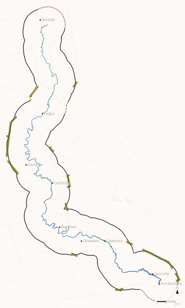
| Method | The water: the GRCA Waterbody river polygons touching the main channel, joined; where the river is under 30 m wide and so mapped only as a line, the GRCA Watercourse main channel (primary flow) at its recorded half-width (BUFFER_WIDTH), which is its edge of water; through Belwood Lake and other reservoirs, the river’s own flow line (Virtual Flow). Six statute miles (9,656.064 m) on the ground from that water, drawn in NAD83 / UTM 17N (EPSG:26917) at 9652.818 m on the grid (the projection’s mean scale 0.999664), its curves drawn with 96 points to each quarter circle and a point at least every 60 m. |
|---|
| Accuracy | At 4000 points round the line, measured on the ground (geodesic, GRS80): 9654.58–9657.19 m from the water, median 9656.05 m — -1.48 to +1.12 m of six miles |
|---|
| Limitations | Grade C: through reservoirs, measured from the river’s own flow line.
Grade D: the rounded end at Lake Erie, and beyond the head of the river — interpreted.
Survey lines are used here as evidence of where the Crown’s surveyors placed the six miles on the ground; relying on them does not accept the instruments behind them. |
|---|
| Survey | This is the Nation’s determination, made from the sources named; it is not a survey under the Surveyors Act, and was not prepared by a licensed surveyor. |
|---|